
Table of Contents:
Automatic View Synchronization
The Split View module is a tool that streamlines work with spatial data and photo documentation. It enables you to analyze the map or 3D scene context and view detailed photos simultaneously in a single browser window.
The browser window is divided into two sections:
- Left side: map or 3D scene
- Right side: photos and annotation tools.
TIP: The feature is available for both standard RGB photos and 360° panoramas.
Activating Split View
You can activate Split View in two ways:
- From the map/scene: Click the icon representing a photo on the map.
- From the table: Open the selected photo from the data table.
Photo Module
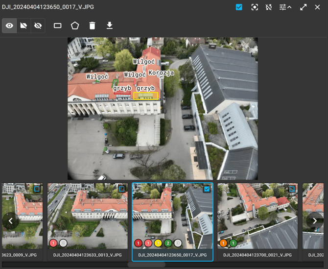
The photo module consists of three main areas:
1. Top bar:
-
File name,
-
Photo marking,
-
View synchronization,
-
Automatic view synchronization,
-
Tools menu (a set of tools for adding and editing annotations, as well as deleting and downloading the photo) — displayed directly above the photo.
TIP: Would you like to learn how to manage annotations? See the “Annotations” article.
TIP: Standard full-screen mode (Fullscreen) remains fully available for users who prefer working in this mode.
2. Center: The currently displayed photo together with its annotations.
3. Bottom panel (thumbnail carousel):
- Navigation: You can switch between photos using the directional arrows or the virtual scrollbar, which makes it easier to quickly navigate to photos further along in the project.
- Annotation preview: Each thumbnail displays a summary of the annotations added to the photo, grouped and highlighted by severity level.
- Photo marking status: An icon in the upper-right corner of each thumbnail indicates whether the photo is marked (yes/no).
NOTE: All actions related to photo management and annotation editing update the photo table.
Matching View to Photos
An additional feature of the Split View module is the ability to perform spatial data analysis directly from the camera’s perspective. Two new view-linking modes are available.
IMPORTANT: View synchronization features are available only for standard RGB photos.
View Synchronization
This mode adjusts and directs the map or 3D scene view to the position and orientation of the currently displayed photo.
To activate this feature, select a photo from the carousel and click the “Synchronize views” icon.
Automatic View Synchronization
Automatic view synchronization is a continuous mode in which the map or 3D scene in the left panel automatically adjusts to the location and orientation of subsequent photos selected from the carousel.
To enable or disable this feature, use the icon shown in the video, located at the top of the photo module.